Thursday, March 17, 2016

J is for Jardin du Palais Royal

One of my favorite spots in Paris holds a special place in my heart.

Lined with ornamental gardens and rows of trimmed trees, the Jardin du Palais Royal is the perfect spot to sit, talk with your lover or even get engaged! In 2009, the latter is exactly what happened to me! You can read about my Perfect Proposal in Paris here. Later this month, we'll celebrate six adventurous years together!

In October, hubby and I returned to the City of Lights in order to reconnect with his brother and his wife whom we haven’t seen in person for two years. The four of us had a blast eating, drinking and sightseeing our way around the city. (That sounds like another blog post in the making!) Of course, we had to show off the jardin!
Just a short stroll from the Louvre, the nearly 400-year-old gardens are tucked behind the neoclassical Palais Royal (closed to the public). The palace and its ornamental gardens were constructed in 1633 and even housed the royal families up until the Palace of Versailles was built in the late 17th century.

With its beautiful roses and other perennials, these gardens are the city’s only ones to be classified as a “Remarkable Garden” by the French Ministry of Culture. The jardin is truly a peaceful haven and a place where romance can bloom in the French capital!

I’m linking this post to the monthly travel guide link up organized by Fiona, a fellow Australian blogger, at Tiffin Bite Sized Food Adventures. Each month features a new letter of the alphabet. This month is the letter “J.” Please pop on over to Fiona’s blog to read more travel stories!

TIFFIN - bite sized food adventures -
My Traveling Joys

Wednesday, March 16, 2016

Sometimes you just need to pick a random spot on the map and simply stop for awhile.

Needing a break from our 5-hour drive from the Pancake Rocks at Punakaiki to the town of Blenheim, we decided to make a pit-stop at Nelson Lakes National Park. We had driven along windy mountain roads and seen breathtakingly beautiful landscapes. Now we wanted to stretch our legs amongst that beauty!
The national park covers 102,000 hectares, including steep mountains, vast forested valleys and two alpine lakes. We stopped at the smaller Lake Rotoiti, located just a short distance off the highway in the tiny village of St. Arnaud. We popped into the information center to see what type of hikes were available. Luckily, there are several short nature walks as well as 3-to-5-day backcountry tramping trails in the park and around the lakes. (Interestingly, hiking is known as tramping in NZ.)
Since we didn’t have a lot of time, we chose a fairly easy 1-hour hike/tramp on the peninsula, closest to the info center, which took us along Kerr Bay and through a forested area. (Here’s a map of the walking trails.)
Our tramping trail along Lake Rotoiti.
Lake Rotoiti and its more famous neighbor, Lake Rotorua, were created by volcanic eruptions about 240,000 years ago. The lakes are known as small waters and large waters, respectively, in the Maori language. These crystal clear “crater lakes” are home to the Southern Alps in New Zealand.

You could almost use the lake as a mirror – that’s how pure and flawless the water was!
As we walked along the lakeside, I also imagined how peaceful it would have been to take a kayak out on the lake’s waters. If only we had more time! Or to pitch a tent nearby and look up at the starry skies at night.
Alas, we had just enough time to enjoy our hike and make it before closing at our first winery in Marlborough, which will be a story for another post!
Before we arrived at Lake Rotoiti, we stopped in the nearby town of Murchison and had lunch at the Vault Cafe. I had a delicious BLAT sandwich on gluten-free bread.
My Traveling Joys

Wednesday, March 9, 2016

Exploring Punakaiki on NZ’s West Coast


When I read about New Zealand’s Pancake Rocks, I knew we needed to see them in person.

So, what the heck are the Pancake Rocks?

Located 40 minutes north of Greymouth, the Pancake Rocks are these remarkable limestone formations that were created about 30 million years ago when lime-rich fragments of dead sealife were deposited on the seabed and then covered with layers of soft mud and clay. Over time, the seabed rose above sea level because of earthquakes; then Mother Nature in the form of water and wind, transformed the rocks to what we see today. 

However, geologists can’t quite comprehend why the limestone decided to stack up on top of each other in pancake-like layers.
So you have this small section of the western coastline that looks like stacked pancakes!

You’ll need about 30 minutes to walk the paved path through the Pancake Rocks park and see all the limestone formations. If you’re lucky, at high tide, the sea is pushed through some of the rocks to create giant blowholes. Unfortunately, we missed the blowholes even though we visited twice and around high tide the next morning. We still enjoyed listening to the roaring Tasman Sea pounding against the ancient rocks.
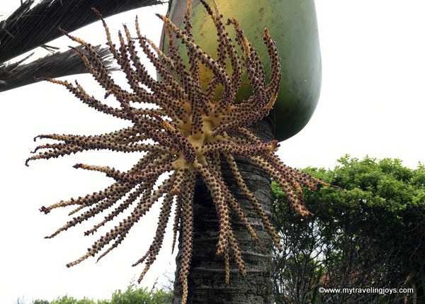
The park and surrounding cool-climate rainforest area is populated by the tall Niaku Palm, NZ’s only native palm tree. The trees produce these strange-looking berries/fruit, which the Maori used to eat. The Naiku’s leaves also were used to wrap food for cooking and to make baskets and waterproof thatch for buildings.
Do you see the different faces/shapes in these rocks? You can't miss the wombat or crouching tiger-looking rock on the right side!

Where to stay in Punakaiki

After taking our TranzAlpine train journey, we decided to stay the night in the tiny, seaside village of Punakaiki, which means “a spring of food” in Maori. We had a 5-hour drive the next day, so this seemed like a good spot to linger. Punakaiki is only about a 10-minute walk from the Pancake Rocks.

We stayed in one of the cozy “cabins” at the Punakaiki Beachfront Motel. Our cabin was about 50-meters from the rocky beach, making it a perfect location for wine o’clock.
We chose having some local wine and cheese over hiking some of the nearby trails in the Paparoa National Park because the day had been filled with rain off and on again. Even if gray clouds peppered the western coastline, we simply enjoyed sitting outside and admiring our view.
Later on, we took a walk along the pebbled beach where I collected some green rocks. However, I don’t think my rocks were the precious jade-greenstone (Pounamu) this coastline is known for.

One thing to note is that Punakaiki contains very, very few food options. We ended up eating at the local pub, which stopped serving dinner around 8 p.m., and it was fine for standard pub-fare. Our cabin had a small kitchenette, and we wished we had stocked up on some groceries before we left Greymouth.
Drizzling evening view of Punakaiki Beach.
Luckily, our morning view at Punakaiki featured these brilliant blue skies!
At least, we remembered to buy some wine. Priorities!

If you find yourself near Punakaiki, be sure to visit the Pancake Rocks and enjoy your beautiful drive along the Western Coast. 

My Traveling Joys

Thursday, March 3, 2016

Riding the Rails from Christchurch to Greymouth


Where does your imagination take you when you think about NewZealand?

Hobbits, perhaps?

Yes, but we didn’t see any playful Hobbits this trip.

However, we did see crystal clear rivers, deep gorges, emerald green grassy-covered hills, brilliant blue-ish purple lupins and more. We couldn’t resist taking the 4.5 hour TranzAlpine Scenic journey, which travels from Christchurch to the small town of Greymouth, located on the western coast. Hubby loves trains, so we decided to pick up a rental car on the other side to continue our road trip.

The KiwiRail website describes this trek as “one of the world’s most famous train journeys”, and we certainly cannot disagree! Hopefully, my photos will be enough to showcase all the natural beauty we saw along the way.
At 8:15 a.m., we departed Christchurch. Even the though the station was crowded, the KiwiRail staff were quite efficient and quickly directed passengers to their reserved cars. First, our journey took across the Canterbury Plains, which covers 750,000 hectacres, making it NZ’s largest area of flat land. That’s where we saw lots of sheep!
Wildflowers
Then, we passed numerous fields of the beautiful Russel Lupins, which I just learned are considered a noxious weed by the NZ Department of Conservation. Unfortunately, these pretty wildflowers can clog up the rivers, thus altering the land where wading birds usually feed. But if you want to see them in bloom, the peak season is generally from November to December on the South Island.
One of my favorite parts of the trip was hanging out in the open-air train car. Luckily, our seats were quite close to one of these cars as they can get quite crowded. Since we traveled in mid-December, the weather was a little chilly (highs in low teens C/about 50F) and people tended not to hang out in the car for too long. However, I tried to brave the blustery winds, set my camera to sports mode and took as many photos as I could as you can see here.
Waimakariri River
Throughout the ride, the ice-fed Waimakariri River, which is the largest of the North Canterbury rivers, flowing for 151km from the Southern Alps to the Pacific Ocean, was our constant companion. I’ve never seen water so pure as this from a distance! We passed over several viaducts and through tunnels as we went through these mountain ranges.
Southern Alps
West Coast
Around the 3-hour mark, we briefly stopped at Arthur’s Pass, which at 920 meters is the highest of only three roads crossing the Southern Alps. The Maori people first passed through here in search of the precious West Coast pounamu (greenstone). The pass is named after Sir Arthur Dudley Dobson who led the first Europeans across here in 1864.

As soon as we descended from Arthur’s Pass through the 5.3-mile-long Otira Tunnel, the weather changed dramatically – from pale blue skies to overcast and rainy. We had reached New Zealand’s West Coast, which is classified as a cool-climate rain forest and known for this type of weather.

We could barely see Lake Brenner, the island’s largest lake in the northwestern part, through the London-like fog.

I happily spent the last leg of the trip in our comfy seats, nibbling on a locally-made ice cream bar. We also finished a bottle of NZ sparkling wine we bought earlier on the train. (NOTE: the café car sells reasonably-priced food and drink, which you can reserve in advance.)
Riding the TranzAlpine made me want to do more train trips! I think this is a fantastic and low-key way to see the countryside.

New Zealand simply seemed filled with picture-perfect landscapes everywhere we looked. I’m already hoping we can return and explore some more!

Do you like travelling by train?

TranzApline train facts:

*The 4.5 hour train ride costs 189NZ (about $126USD). I think there may be cheaper tickets if you can book further in advance.

*I reserved a breakfast wrap and gluten-free berry smoothie in advance. Cost: 14NZ (about $9USD).

*The train also departs from Greymouth every day at 1:45 p.m., heading to Christchurch.

*We reserved a rental car in advance through the local Apex Car Rentals and easily picked it up at the Greymouth train station. Cost: $234NZ (about $150USD) for 3 days. I liked that they did not charge a one-way drop-off fee like some companies do.

My Traveling Joys

Sunday, February 21, 2016

How to Spend 24 Hours in Christchurch


At 6:30 a.m., the lifeless, gray skies only seemed to add to the feeling that Christchurch was a ghost town.

After strolling through the lovely Botanic Gardens, where we saw two other people, we wandered into the city center to find a coffeeshop. After living in Melbourne for the past nine months, we just assumed we would find something open by 7. Maybe 7:30 a.m.

We were wrong.

Christchurch, with a population of 366,000, appeared not to be inhabited until almost 8 a.m. We wandered down main streets lined with silent construction cranes and stone rubble and past vast empty gravel lots where buildings once stood in the city center. We could have been standing in a post-war zone.

Not a soul in sight!
Cathedral Square
We stopped by the historic ChristChurchCathedral, a Gothic Anglican church built between 1864 and 1904, which stands in crumbling ruins behind construction fencing in Cathedral Square. The deadly February 2011 earthquake destroyed the 63 meter-high spire, and subsequent earthquakes in June and December 2011 damaged the church’s stained-glass rose window.

I felt downright miserable that this beautiful church has been left in ruins for 5 WHOLE YEARS while the church, locals and city government argue about what should be done about it. Finally, it looks like the parties (maybe) have agreed to repairs and reconstruction to be completed by 2022 if the building is reinstated by the diocese.

The 2011 earthquake killed 185 people, injured thousands, caused widespread destruction and was felt across the South Island and parts of the North Island. Our taxi driver from the airport told us he had just dropped off a customer and watched a building fall down and the road ripple right in front of him five years ago.

Following the earthquake, a temporary church was built, called the “Cardboard Cathedral,” due to the cardboard tubes used in the building’s ceiling. The Anglican church is still holding worship services and concerts here.
Although the city center still looks like a gigantic construction zone, Christchurch is rebuilding – slowly by slowly. We found several things to enjoy during the 24 hours we had to spend here.

Botanic Gardens
The gardens are located just west of the city center and cover a large area in Hagley Park. We strolled through the beautiful rose gardens and enjoyed seeing the New Zealand silver ferns up-close for the first time.
Popups and Street Art
As we wandered around, we discovered the city’s artistic community has jazzed up the concrete landscape with streetart in the CBD (in a previous blog post) as well as popup stores and art installations.

We found a funky shopping plaza called Re:START City Mall that has been built out of shipping containers and features cafés, locally made goods, clothing and food trucks. This is where we finally found a fun, lively vibe! I bought an Andy Warhol-inspired sheep apron and couple of NZ Christmas ornaments.
Kiwis have such a good sense of humour.
Tree Housesfor Swamp Dwellers, consisting of 10 modular objects identified both as trees and houses, was created by local artist Julia Morison.

Located nearby is a solar-powered table that acts as a power station to charge your electronics such as your mobile phone or Ipod.
Chairs, corner of Cashel and Madras streets, serves as a memorial for the 185 people killed by the earthquake in February 2011.
Art Museum
In December, the Christchurch Art Gallery, home to the country’s largest public art collection, reopened its doors to the public for the first time in nearly five years. I think the gallery’s outdoor neon sign describes the city’s motto well: Everything’s Going to Be Alright.
New Regent Street
If you want to pretend you’re in a live version of Candyland, head on over to the charming New Regent Street, a historic shopping street originally built in 1932. This Spanish Mission-style designed street, known then as New Zealand’s most beautiful street, was built during the Depression years to help boost local shopping. 
We found several restaurants, bars, a bakery that sold amazing cookies and shops selling locally-made tourist goods. We settled in for a thirst-quenching NZ beer at the speakeasy-looking Institution.
 
Local Craft Beers
Near our hotel in the Riccarton neighborhood, we had read about a place called the Volstead Trading Company. (in 1919, the U.S. enacted the Volstead Act to establish Prohibition.) Since we loved watching the American series Boardwalk, which takes place during the Prohibition era, we thought this would be an appropriate place to grab an afternoon beverage. This bar featured local craft beers, comfy chairs and a laidback environment – a perfect place to rest our weary feet. I loved my pink cider beer made from Red Gala apples!
Creative Food
Unsure of where to pop in for dinner, we checked our reliable Foursquare app to see what looked good nearby. That’s how we ended up at the popular Fiddlesticks Restaurant and BarWell two of the dishes I have photos of are the seared scallops and locally-cured NZ salmon with pickled ginger – both were delicious! The restaurant also had a nice selection of NZ wines by the glass.

Today, as the residents of Christchurch remember the five-year anniversary of the 2011 earthquakes and those who died, let’s not forget to support this city. I believe the city, like the Phoenix, will continue to rise from the ashes and soar again!

If you are traveling to New Zealand, be sure to spend some time in Christchurch and help this friendly community rebuild.
Playing in an old-fashioned telephone booth in Christchuch.
The rose garden in the lovely Chateau on the Park, where we stayed for one night. The hotel offered a free shuttle bus ride to the train station, one of the reasons why I chose it; however, for convenience sake I wished I had selected one of the hotels in the city center. We ended up walking more than 10km since it was about 2 km from the hotel to the CBD.
My Traveling Joys