Exploring Punakaiki on NZ’s West Coast
When
I read about New Zealand’s
Pancake Rocks, I knew we needed to see them in person.
So,
what the heck are the Pancake Rocks?
Located
40 minutes north of Greymouth, the Pancake Rocks are these
remarkable limestone formations that were created about 30 million years ago
when lime-rich fragments of dead sealife were deposited on the seabed and then
covered with layers of soft mud and clay. Over time, the seabed rose above sea
level because of earthquakes; then Mother Nature in the form of water and wind,
transformed the rocks to what we see today.
However, geologists can’t quite comprehend why the limestone decided to stack up on top of each other in pancake-like layers.
However, geologists can’t quite comprehend why the limestone decided to stack up on top of each other in pancake-like layers.


So
you have this small section of the western coastline that looks like stacked
pancakes!
You’ll
need about 30 minutes to walk the paved path through the Pancake Rocks park and
see all the limestone formations. If you’re lucky, at high tide, the sea is
pushed through some of the rocks to create giant blowholes. Unfortunately, we
missed the blowholes even though we visited twice and around high tide the next
morning. We still enjoyed listening to the roaring Tasman Sea pounding against
the ancient rocks.


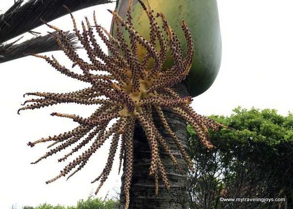
The
park and surrounding cool-climate rainforest area is populated by the tall
Niaku Palm, NZ’s only native palm tree. The trees produce these strange-looking
berries/fruit, which the Maori used to eat. The Naiku’s leaves also were used
to wrap food for cooking and to make baskets and waterproof thatch for
buildings.

 |
| Do you see the different faces/shapes in these rocks? You can't miss the wombat or crouching tiger-looking rock on the right side! |
Where to stay in Punakaiki
After
taking our TranzAlpine
train journey, we decided to stay the night in the tiny, seaside village
of Punakaiki, which means “a spring
of food” in Maori. We had a 5-hour drive the next day, so this seemed like a
good spot to linger. Punakaiki is only about a 10-minute walk from the Pancake
Rocks.
We
stayed in one of the cozy “cabins” at the Punakaiki Beachfront Motel.
Our cabin was about 50-meters from the rocky beach, making it a perfect
location for wine o’clock.

We chose having some local wine and cheese over hiking some of the
nearby trails in the Paparoa
National Park because the day had been filled with rain off and on
again. Even if gray clouds peppered the western coastline, we simply enjoyed
sitting outside and admiring our view.

Later
on, we took a walk along the pebbled beach where I collected some green rocks.
However, I don’t think my rocks were the precious jade-greenstone (Pounamu) this
coastline is known for.
One
thing to note is that Punakaiki contains very, very few food options. We ended
up eating at the local pub, which stopped serving dinner around 8 p.m., and it
was fine for standard pub-fare. Our cabin had a small kitchenette, and we
wished we had stocked up on some groceries before we left Greymouth.
 |
| Drizzling evening view of Punakaiki Beach. |
 |
| Luckily, our morning view at Punakaiki featured these brilliant blue skies! |
At least, we remembered to buy some wine. Priorities!


